Regina – In many ways, the history of Dr. Jim Christopher, PhD, professional geologist, is that of the Saskatchewan Geological Survey. He’s been there most of its 70-year existence. And at age 93 as of July 30, he is still there, despite having retired in 1987. Deep in his office, behind massive piles of books and papers, he’s still plugging away, for free, in 31-year-long period of post-retirement work that has been longer than most people’s careers.
Christopher’s work is notable for much more than his longevity, however. His research in the Jurassic in the southwest and the Bakken has fundamental in literally billions of dollars of development work in recent decades. Thousands of jobs in Saskatchewan today are the result of the foundational work he did in these areas, because, after all, it all starts with the rocks. And if that’s the case, the next step is the person who interprets them.
Pipeline Newsspoke to Christopher at length on Feb. 9 in preparation for this edition. In late June he was still in his office at the Saskatchewan Subsurface Geological Laboratory, also known as the core lab, still plugging away.
Indeed, at the start of the interview, his fellow geologists pulled out one of Christopher’s seminal papers on the Mannville formation, published in 2003, 15 years ago. And that was completed long after he had retired.
He came in 1959
Christopher started working in Saskatchewan in 1959 with the Department of Mineral Resources.
He was born in Philadelphia, raised in Jamaica from ages 9 to 18, then returned to the U.S.
According to his biography listed in the Saskatchewan Oil Patch Hall of Fame, Christopher worked as a migrant farm labourer before joining the U.S. military, and he arrived in the European theatre of war in time to become a member of the U.S. Army of Occupation. After demobilization, Chris worked as a civilian employee with the U.S. Army Map Service in Washington, D.C., but eventually returned to his family home in Jersey City where he took employment in the manufacturing industry. At the same time, he began university night classes at the community college level and moved on to Columbia University, graduating with a bachelor’s degree in geology, which he completed in 1951, attending on the G.I Bill.
Armed with his bachelor’s degree and scholarship funding, including the John Hay Whitney Fellowship, and John A. Bownocker Scholarship, he proceeded to Ohio State University to continue his geological training toward masters in 1955 and doctorate in 1959. His doctorate was in contemporary sedimentation, working on landslides in the bluffs along Lake Erie and the movement of sediments along the shore in eastern Ohio, impacted by the rise and fall of the lake level as well as the climate.
He married Dora in 1957. They were married for 45 years before her passing in 2002. They had six children, three boys, three girls. None took up geology, however.
Upon completion of his doctorate, Christopher and family came straight to Saskatchewan. “I collected my diploma, gathered up my belongings, put them in a car and drove up here. I saw a job advert on the bulletin board at Ohio State. It was from the department here,” Christopher said.
All they had fit in that ’53 Plymouth.
The job was in research geology in sediments. “It was the beginning of the research group in the department.”
“There were three of us – Don Kent, who was already here, he’s a Canadian, and then LLewelyn Jones. He moved on after six years. He came the same time I did.”
John Brindle was the supervisor at the time. There was just the four of them for sedimentary geology, and others for the geological records section.
The core lab building was built in 1957, and he’s worked there ever since 1959. He became a Canadian in 1967.
Foundational work on the Bakken
The early 60s saw a boom going on. “When we drove up from the border from North Dakota, crossing at Northgate, we drove up through Estevan. Main street was mud, and the sidewalk was boardwalk. The oil boom started in about 1955. It was in the full throes of growth, I would say,” Christopher said.
“The first thing I worked on, of all things, was the Bakken, which was totally discounted at the time. So the report on the Bakken became the fundamental report for the big boom of the 2000s. The huge crush now, you could put it back to 2008,” he noted.
His original, basic study of the Bakken was done in 1961, the same time Jones did one on the Viking formation in west central Saskatchewan.
Christopher said his study roughed out the framework for the Bakken basin. He visited all the outcrops in Montana for the Bakken. “Most of the outcrops come to the surface in Montana. Much of the early history of the Bakken was done by the U.S. Geological Survey (USGS) in the early 1890s,” he said.
These were week-long trips, going from outcrop to outcrop, using expertise from the USGS. “The Little Rocky Mountains was the closest, five hours south of the border. The rest were further afield, and west,” he said. Other explorations in the Bearpaw Mountains looked at outcrops of the Jurassic and Cretaceous periods.
“None of the rocks we studied really outcropped in Saskatchewan. Montana has all the outcrops and North Dakota has all the oil,” he said.
He explained that the outcrops of the Bakken are very consistent with core drawn from it.
“It’s a sandwich – upper shale, middle sandstone with silt, and lower is black shale, and is thicker, usually two or three times thicker than the upper shale. But it’s not really thick, as far as formations go. Sixty feet is a lot of shale.
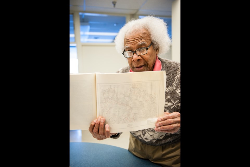
The structure maps he pulls out are maps he, himself, drew of the Bakken. Christopher noted that in North Dakota, they produce directly from the shale, where as in Saskatchewan, Bakken production is mostly from the sandstones.
The early reports on the Bakken were based on drilling chips and some cores from early wells. “And then you guess, by God, between points. That’s what you call prospecting,” he said with a laugh.
“This one (study) had only 440 wells, from the Manitoba border to 14-W3, down towards Swift Current, and mostly south of township 30, because there’s no Bakken north of there.
His conclusion, back then, described the basin, depth, the type of environment the sediments were laid down in, and a prediction of old shorelines, if there were any.
“In terms of the oil, we described all the oil shows found, the well depths, there in the report, and described all the cores present that were used. And we had a chapter on economic possibilities.
“The economics was mostly in the sandstone, at the time. The oily nature of the shales were observed, but not considered recoverable at the time.”
The USGS came out with big numbers for the Bakken North Dakota and Montana, back in the 1980s, but it still took another two decades to develop.
Along the way, Christopher worked on the Torquay formation, which has, in recent years, become one of the hottest plays in Saskatchewan. At the time of the interview, Crescent Point Energy Corp. had nine drilling rigs working in one township, just southwest of the village of Torquay and along the U.S. border.
“I named the formation,” he said, matter-of-factly.
“It’s part of the Bakken report. I described the Torquay.”
Manitoba and North Dakota call the same formation the Three Forks. Asked why he named it the Torquay, he replied that the original Three Forks included the Bakken and the underlying shales. “I interpreted the Three Forks group and then I separated out the Torquay as a separate unit,” he said.
The name Torquay was a matter of convenience, chosen from a well that was fairly completely cored, and named the formation after the nearest town or village, if it was not pre-empted by another name or formation.
Jurassic in the southwest
After his initial work on the Bakken, he then worked on the Jurassic in southwest Saskatchewan around Shaunavon. “That came out in ’64, I guess. That was a very lively time, in terms of drilling and prospecting,” he said. “There was a lot of pressure on that one to get it out. When we started with that report, the Bakken, the companies didn’t believe us, didn’t believe we were real, because all knowledge resided in Imperial Oil or Shell, and the government couldn’t contribute anything. Back then the government approached one of the companies, I won’t say which one, and asked, ‘How can we help you in terms of geological studies?’ This is why they wanted to form this division.
“They said, ‘Oh well, you could have those guys put points on the map and we’ll draw the lines in between.’”
Imperial and Shell had big study groups that studied whole basins, he noted. They didn’t have much use for government. Christopher noted the CCF had recently come in as the government, and the government and companies each had their own ideas of what they wanted to do.
Asked if his 1964 study spurred any activity, he smiled and said, “Oh, did it ever!”
He said an American celebrity was brought in to see the facilities, and that celebrity was introduced to him as “the geologist responsible for a million dollars in land sales.”
“This was a hectic time. I couldn’t keep up with the data coming in so fast. And the communication between the industry and department were very good in those days.”
“That was what distinguishes Saskatchewan from lots of other places in the States, in that we have this central core repository, and this data is available.”
The first Jurassic study was for the Shaunavon area, looking at the middle Jurassic. The second study, looking at the upper Jurassic around Swift Current, was completed 10 years later, in 1974. He put about eight years into that study. It incorporated all the southwest portion of the province.
“The deputy minister wanted to know what was holding this report up,” he said. There was a controversy between two oil companies at the time, Ashland and Mobil. His preliminary paper reversed some ideas held at the time, and Ashland was not happy about it. His report settled the matter. “After the Shaunavon report, my reputation was strong enough to be accepted by the major companies,” he said.
In the latter half of the 1970s, he worked on the Mannville formation.
“Companies start with these reports and build their prospects on it. That was our mandate, for exploration in the province,” he said. “So we have lots of these reports, of other formations.
He was one of the initial organizers of the Williston Basin Petroleum Conference.
In the 1970s and 80s he was supervising field parties that went into the Athabasca basin in northern Saskatchewan. He would dispatch them from Regina and check up on them from time to time. His time became more consumed with administration as he worked up through the ranks, rising from senior research geologist to principle research geologist in charge of the research section and on to chief geologist of the sedimentary geology division and eventually to director of the Saskatchewan Geological Survey in 1982. There were 55 people working under him at the time.
His tenure as Saskatchewan’s chief geologist took place during the time of the Grant Devine administration. The energy minister for a time, and Christopher’s boss, was none other than Colin Thatcher.
Among his many honours, he was in the first batch of inductees into the Saskatchewan Oil Patch Hall of Fame, in 1989.
Christopher took early retirement in 1987 but continued to work with enthusiasm on his favourite topic, the Lower Cretaceous rocks of Saskatchewan. That work reached fruition in 2003 with the release of S.I.R. report 223 – “Jura-Cretaceous Success Formation and Lower Cretaceous Mannville Group of Saskatchewan.”
Even after seventeen years of ‘retirement,’ he continued to act as a geological consultant to oil and potash companies, and was involved in two regional mapping projects, the Weyburn CO2 storage and sequestration project, and TGI.
Retirement, or not so much
He retired in 1987. Well, sort of. He’s continued to often put in five days a week, going for beer on Fridays, ever since, except without the government paycheque.
He was a victim of the big oil downturn at the time.
“In ’87, there were big government cutbacks. So that’s when the Geological Survey lost ten members, including me,” he said. He was offered a two-year contract to work on the Mannville, which he had already started on, on his own time. It was to be a bridge to his retirement.
The Mannville report actually took 15 years of off and on work. The government supplied the office and facilities. “But all the map work, and all the core sections, I did by hand. The government finally digitized it, and it was the first of the digitized reports,” he said.
Thus, instead of a thousand printed copies, only two were made, one for the library, and one for him.
He put in tens of thousands of hours into this report, unpaid other than his pension.
Companies who sought to have certain areas studied would hire him to do that, and it would find its way into the report, so there was some pay from that, but it was primarily for use of the lab, as opposed to income.
It was essentially a labour of love. “It grew because of the circumstances, there was no money to publish it to begin with, and so I added to it. Each time it was submitted for the editorial process, there would be delays, so I kept adding to it. So finally, I think in self defence, they published it,” he laughed.
Not only is the Mannville formation key for heavy oil production in northwest Saskatchewan, it’s also the formation that has a tendency to flood potash mines, he noted.
“What distinguishes the Mannville is it covers every formation, or blankets the edge of every formation in Saskatchewan, from the border to the sedimentary edge, because it’s laid down on an old land surface which infilled,” Christopher said. It can be anywhere from 20 to 200 metres thick, thicker to the northwest.
Fundamentally, he was the guy who never knew when to go home. “That’s what it came down to,” he said. “It was not only work, but a hobby, also. But everything I knew about the Mannville, I put in there. The idea was to make it as useful as possible, whether it be for oil or solution for potash problems, or water quality.”
That report was completed 15 years ago. Since then he’s also worked on federal-provincial agreements, including working on the geology for the Weyburn-Midale Project, and a joint Manitoba-Saskatchewan mapping project. Currently he’s mapping the formations of the Colorado, to try to standardize the nomenclature, and to explore aspects of its deposition.
He’s hoping to publish his results this year.
“I don’t plan to do anything more than that,” he said.
Is he calling it quits?
“I think so. It’s getting harder and harder to get out,” Christopher smiled.
So 31 years after he retired, Dr. Jim Christopher might actually retire.
“Might” is probably the operative word. Don’t count on it. There��are still lots of rocks to explore.
��
70th Anniversary of Saskatchewan Geological Survey Stories
��
��


