Regina – “It all starts with the rocks.”
That’s something you’ll often hear from Dr. Gary Delaney, chief geologist of Saskatchewan. And he’s had the opportunity to say it a lot this year, with the 70th anniversary of the Saskatchewan Geological Survey (SGS) of which he is the head.
The SGS is part of the Saskatchewan Ministry of Energy and Resources, and until recently, had been part of the Ministry of Economy. The ministry names have changed a few times over the years, but the Survey has always had a foundation role in the development of the province’s mineral and petroleum sectors.
Delaney has been doing presentations throughout the year to various organizations about the history of the Survey and the key role it has played in providing geological information that has supported the growth of the province’s minerals and oil and gas sectors which are key pillars of Saskatchewan’s economy.
“It was back in the late 19th and early 20th century when some of the earliest geological surveys were done in the province. Those were very much regional reconnaissance work by the Geological Survey of Canada,” he said on June 7. “Their geologists went up north, and canoed along all the major rivers, to see what was going on in terms of the geology.
“The government of Saskatchewan first got into the geology of mineral resources back in 1920, when the Saskatchewan Bureau of Labour and Industries was established to survey and promote industrial resources. Subsequently, the University of Saskatchewan was engaged and began pioneering work on the geology of Saskatchewan. Key players were J.B. Mawdsley, who led several geological mapping expeditions in northern Saskatchewan, and F.H. Edmunds, whose work focused on understanding sedimentary rocks that underlie the south,” Delaney said.
“The seminal point for the province’s resource sector was October 1, 1930. That’s when the Dominion of Canada transferred ownership of mineral resources (both minerals and oil and gas), to Saskatchewan. This is not unique as in Canada today, natural resources: minerals, oil and gas, belong to the provinces and territories,” Delaney said.
Subsequently there was a flurry of geological mapping that started in southern Saskatchewan in 1930. Then, during the period 1934-40, the Geological Survey of Canada undertook some mapping, in the Precambrian shield of northern Saskatchewan. By 1947, they released the first geological map for the whole province, replete with holes due to missing information in places.
In 1947, the then-Saskatchewan Department of Mineral Resources created a Mineral Resources Branch. “They started doing prospector schools up in La Ronge and various other assistance programs. But the real seminal event was in 1948, when the Saskatchewan Geological Survey was established. Its mandate was to map the northern mineral areas, as well as carry out geological surveys of potential gas and oil areas and other economic minerals of southern Saskatchewan,” he said.
That dual mandate has carried on since then.
In the 1950s it was put under the administration of a chief geologist. Resident geologist offices were established in Goldfields, near Uranium City, and Prince Albert. Several geologists were added to petroleum geology as well.
“About this time an interest was developed in archiving the various petroleum drill cores that had been collected. Some were stored up in Saskatoon in the basement of a Saskatchewan liquor board store. These were moved to an abandoned chicken processing facility in Regina which became the province’s first core lab,” he said.
That building was a precursor to the current Subsurface Geological Laboratory, which was built in 1958. It has been expanded numerous times since then. It was the first such facility in Canada, and one of the first in North America.
“Someone realized that core was a valuable resource, so we started collecting and archiving it,” Delaney said.
The facility currently stores core from 22,644 wells. If you lined those cores up end to end, it would stretch 640 kilometres, almost exactly the length of the TransCanada Highway from the Manitoba to Alberta borders. It fills 426,793 boxes. There’s another 5.5 million vials of drill cuttings from over 41,000 wells.
In the 1960s there was a lot of geological work done by the Survey on the Prairie Evaporite formation in support of potash exploration. “The discovery of potash in that formation really happened as a result of the interest in our oil and gas resources. Potash was discovered in south central Saskatchewan in 1942, near Radville, at a depth of 2,332 metres,” Delaney said. Another discovery happened the next year near Ogema. A third, cored well in 1946 found 21.6 per cent K2O, the active ingredient in potash, over 3.35 metres at a depth of 1,056 metres.
The first attempt at potash mining was in 1951 at a solution mine near Unity, and a shaft mine that failed a few years later in 1968. Patience Lake, near Saskatoon, began mining in 1958 as an underground mine, but flooding resulted in it becoming a solution mine. Today there are 11 underground or solution potash mines which account for about 30 per cent of the world’s production. As Saskatchewan contains 45 per cent of the world’s potash reserves, Delaney said this industry has a long future.
Coal mining has been ongoing for many years along the U.S. border.
Petroleum
Drilling in the Western Canada Sedimentary basin began in the 1870s. Natural gas was encountered near Lloydminster in January 1934. That led to the discovery of the Lloydminster gas pool, which is still producing. During the 1930s, there were 103 wells drilled, including 11 successful gas wells.
“Oil was first noted in 1935 in the Lloydminster area, but it wasn’t commercially viable. A lot of exploration took place in the 40s, and new gas pools were discovered in the Unity area. We started to produce a significant amount of natural gas. Commercial quantities of heavy crude oil were discovered in the Lloydminster area in 1943 in Alberta and 1944 in Saskatchewan,” Delaney said.��
“The Geological Survey was formed in 1948. Some of our geologists started studying the nature and context of these oil and gas reserves. We started collecting technical information, archiving data and core from drill holes. We took that role that a government geological survey can do, of putting together more of the provincial picture, the big with some detail of what are the nature and context of these resources, and where do you find them. That work has been carried on to today,” Delaney said.
Dr. Chao Yang, for instance, a research geologist with the Survey, did a lot of foundational geology that helped companies go out and explore for the most recent round of potash exploration and development that’s taken place over the last decade.
“We’re really the folks that establish that geological framework for the province. If you don’t understand the geology, it’s hard to explore, be it coal, be it oil and gas, minerals or whatever. A lot of big, big companies will have a lot of resources, but a lot of the smaller guys have really relied on us.”
The Survey builds the geological architecture, providing a picture of where the units are, and their shapes. For example a work by Milt Holter in the 1960s supported a lot of the early potash exploration and development.
Dr. Jim Christopher and Dr. Don Kent also put together maps showing where various units were in Saskatchewan. (See related story, Page A??)
Supporting exploration
Delaney joined the Survey in the mid-1980s. Over time he said there’s always been a few people working on potash, both more and more the focus of their work in southern Saskatchewan has been on petroleum geology. “The work that’s been done here has led to the development of a number of oil pools. Our geologists can look at the whole picture. They will research an idea, put it out in papers and the Prospects series and present it in technical sessions at various conferences. This work helps industry think of new ideas and places to explore.
The Prospects series are small publications that highlight focused research in particular area. They are routinely produced by the Survey’s geologists on an ongoing basis.
To keep mineral claims in good standing, companies must provide technical reports on their exploration programs (confidential for three years). “We literally have millions of pages of these reports, going way back. Two years ago we undertook an initiative that scanned that information, so somebody coming in that wants to work on a mineral project, can go online and find reports and maps from previous industry work.”
Maintaining the province’s geological information, be that cores, technical reports or maps, is one of the Survey’s key roles
“We are the keepers of the provincial geological database,” Delaney said. “You have to look at geological data as infrastructure. You have roads, you have power lines, but we understand the geological architecture of the province. We take that to build 3D models, research papers, maps and so on. That’s infrastructure. We have all that information. We make it freely available. It contributes to the province’s competitiveness.”
��
��
��
��
��
Next generation of geologists
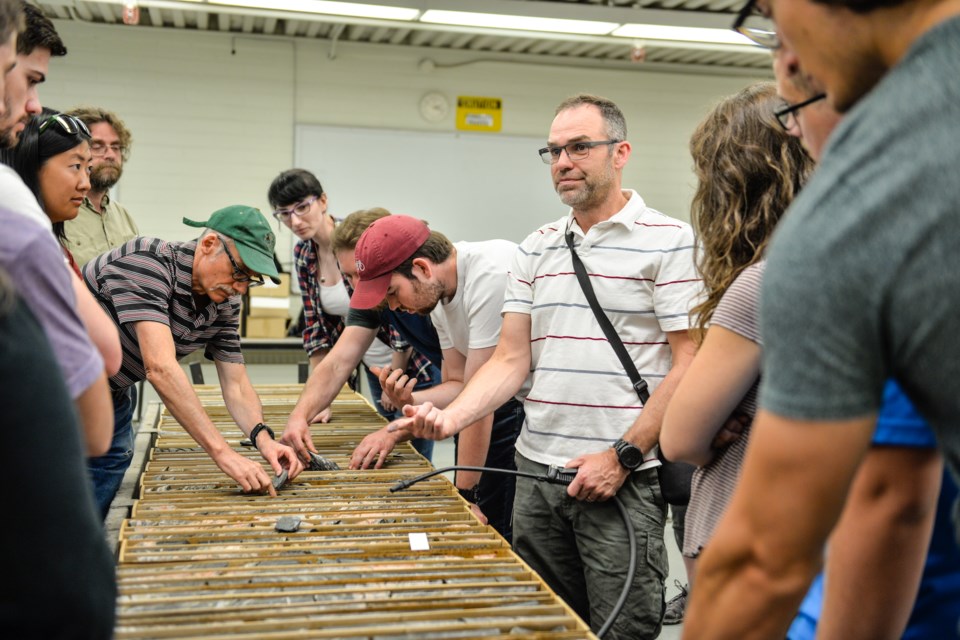
While the interview with Dr. Gary Delaney was going on, a number of summer students were being briefed in the examination area of the core lab. Standing between the roller racks upon which countless core have been closely examined by squinting geologists, the fresh faces represent the next generation of geologists for the industry.
“These are undergrads in geology programs at Saskatchewan’s two universities. Working for us during the summer gives them some great technical training. Some of them may end up joining us and be supported to obtain graduate degrees. We really have a fundamental role in training the next generation of geologists,” he said.
“We also do a lot of international cooperation,” he said, noting they have cooperation agreements with geological surveys in China and Australia.
Delaney pointed to Dr. Colin Card, an adjunct professor with the University of Regina, and a member of the Survey’s staff. Card was the man briefing the students. Delaney said, “Years ago, he worked for me as a summer student, up in northern Saskatchewan.”
Pointing to another person in the room, he said, “Peter Hill, he’s been working for us for a few years now after spending some time in industry. He just completed his masters degree. We supported that as part of his work plan.”
Dr. Kathryn Bethune, chair of the Geology Department of the University of Regina, was also present. She said, “The University of Regina, and University of Saskatchewan, to some extent, work very closely, with the Survey especially in terms of research and training students. A lot of the research we do is field orientated. We work collaboratively on those field projects,”
She noted the Survey’s and universities’ personnel work closely to train students in geology field techniques.
Delaney and Bethune noted University of Regina geology students use the core lab in their lab classes. “The students can come here and see the rocks,” Bethune said.
Students are able to access cores free of charge.
“There is a really good synergy between the University of Regina and the Saskatchewan Geological Survey,” Bethune said.��
��
70th Anniversary of Saskatchewan Geological Survey Stories
��
��
��
��
��
��
��
��


